Wildfire Resilience in Power and Energy
Geospatial Technology: The Foundation for Fire-Resilient Energy Systems

In Parts 1 and 2 of this series, we examined how the risk landscape for wildfires is evolving and how environmental factors are influencing the problem. The conclusion was clear: energy systems are deeply entangled in the wildfire challenge—both as potential ignition sources and as highly vulnerable assets.
In this post, we are transitioning to the role of geospatial data and analysis in building fire-resilient energy systems. Strategies around resilience must be grounded in something more substantial than reactive measures or seasonal planning. They require a continuous intelligence from layers of input. This is where geospatial technology becomes essential. By combining remote sensing, advanced modeling, and analytics, geospatial tools provide the foundation for detection, prediction, and decision-making at the speed and scale resilience demands.
Sensors: The Building Blocks of Fire Intelligence
At the heart of any geospatial system are the sensors that capture raw data. Each sensor type offers a unique perspective on the landscape. When combined, they create a layered perspective that extends far beyond what a single technology can provide.
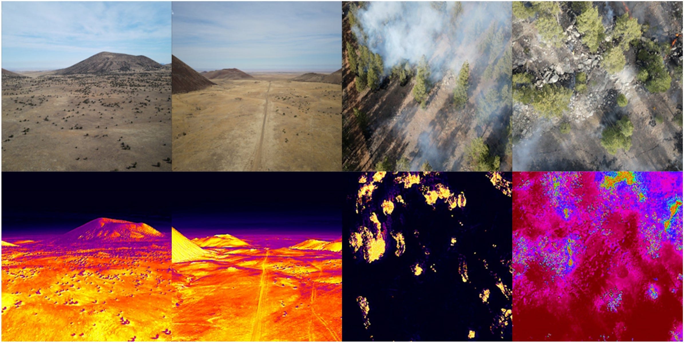
LiDAR (Light Detection and Ranging) generates highly accurate information about terrain and vegetation structure. For energy operators, this means precise mapping of vegetation encroachment around power lines or pipelines. LiDAR can also capture slope steepness and ground conditions, helping identify where landslides and fire interactions might pose compound threats.
Synthetic Aperture Radar (SAR) uses microwaves to actively illuminate the surface, producing data day or night, even through clouds or smoke. SAR excels at monitoring soil moisture, surface deformation, and burn scars—all critical indicators in wildfire monitoring. It ensures continuity when visibility is poor, which is often the case during fire season.
Multispectral Imaging sensors collect data across a handful of spectral bands, typically in the visible and near-infrared range. They are invaluable for tracking vegetation health, moisture content, and fuel load. Before a fire starts, multispectral imagery helps identify areas of high ignition potential. After a fire, it provides a rapid assessment of the damage.
Hyperspectral Imaging sensors divide the electromagnetic spectrum into hundreds of narrow bands, enabling highly detailed material identification. For wildfire resilience, this can mean detecting early signs of vegetation stress invisible to the human eye, or distinguishing between invasive grasses and native species. Both are powerful signals of future fire behavior.
Thermal Infrared Imaging detects heat signatures, making it critical for spotting ignitions in their earliest stages and tracking active fire fronts. Also identifies hotspots after suppression, thereby reducing the risk of reignition.
Weather and Microclimate Sensors IoT systems measuring wind, temperature, humidity, and fuel moisture. They refine ignition probability models and establish guidelines for operational actions, such as Public Safety Power Shutoffs.
Gas and Air Quality Sensors detect methane leaks, smoke plumes, and combustion signatures. Provide early warnings of infrastructure failures while helping quantify the community health impacts of wildfire smoke.
Outcome: No single sensor provides the whole picture. But together—multispectral, hyperspectral, LiDAR, SAR, thermal, weather stations, and gas/air monitors—form a multi-layered intelligence system. This fusion enables operators to monitor fuels, track ignitions, assess infrastructure vulnerabilities, and model fire behavior with far greater accuracy.
Platforms: Where Sensors Meet the Mission
Sensors alone don’t solve the problem. Their value depends on the platforms they ride on—each with unique strengths for wildfire resilience. By aligning sensor capabilities with the right platform, operators can strike a balance between continuous monitoring, accuracy, and fidelity.
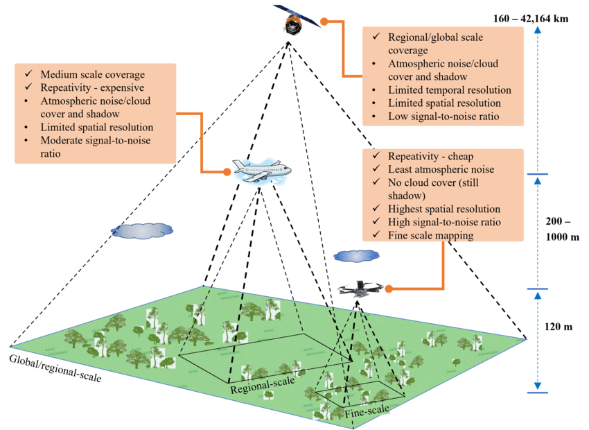
Satellites: Continuous, Wide-Area Monitoring provides consistent coverage at regional to global scales. Best for spotting vegetation stress, detecting thermal anomalies, and supplying historical context. Limitation: revisit times and resolution.
Fixed-Wing and Rotary Aircraft: High-Accuracy Mapping with LiDAR, hyperspectral, or thermal payloads, they deliver detailed corridor-scale surveys. Ideal for annual or seasonal monitoring of energy corridors like transmission lines or pipelines.
Uncrewed Aerial Systems (Drones): High-Fidelity, Local Insights provide ultra-high-resolution data with the flexibility to revisit hotspots frequently. Best for validating risks, monitoring vegetation encroachment, or post-fire infrastructure assessments.
Terrestrial and IoT Platforms: Continuous Local Sensing, including ground-based stations, cameras, and weather sensors, delivers immediate, asset-level awareness. Essential for microclimate data, soil moisture monitoring, or detecting nearby ignition hazards.
Outcome: By layering satellite continuity, aerial accuracy, drone fidelity, and terrestrial immediacy, operators gain a multi-scale resilience toolkit. Each platform fills a different gap, and together they enable both the “big picture” and the “last mile” view of wildfire risk.
Baseline: Establishing Operational Awareness
The first step in building fire resilience is to establish a baseline—turning streams of sensor data into actionable operational awareness. This process begins with the reconstruction of a three-dimensional digital twin of the operational footprint. An aerial LiDAR survey provides the structural foundation, mapping buildings, vegetation, and above-ground infrastructure. Layering in multispectral imagery acts as an early scout, exposing stressed vegetation and fuel buildup that are invisible to the naked eye. Together, these datasets create a clear picture of current conditions—the foundation upon which all resilience strategies are built.
Detection: Enabling Active Situational Awareness
With the baseline in place, the focus shifts to detecting ignitions and evolving risks. The sooner a fire is identified, the more effective the response will be. Thermal infrared sensors can register heat anomalies before smoke appears, while satellites sweep across entire regions, continuously scanning for ignition points. At the other end of the scale, drones and IoT thermal cameras provide localized, minute-by-minute monitoring of hotspots. Complementary technologies such as SAR ensure that awareness continues even when smoke or clouds obscure optical sensors. Detection transforms static baseline maps into a living, real-time operating picture.
Prediction: Turning Data into Foresight
Awareness of the present is powerful, but foresight is transformative. By integrating sensor inputs into dynamic models, operators can anticipate where fires are most likely to ignite, how they may spread, and which assets will be at risk. Multispectral and hyperspectral imagery inform models of vegetation stress and fuel moisture, while SAR provides critical data on soil and surface conditions. Terrestrial weather stations provide wind, humidity, and temperature data, enhancing ignition forecasts.
Recent advances in artificial intelligence push this predictive power further. Machine learning systems trained on decades of fire data integrate both natural conditions and infrastructure patterns, producing probability-based forecasts. These models learn from each new season, continuously refining their accuracy. Prediction is no longer guesswork—it is foresight grounded in data, enabling operators to see beyond today’s conditions to tomorrow’s risks.
Decision-Making: From Intelligence to Action
The actual value of geospatial intelligence lies not just in knowing, but in acting. Baselines, detection, and prediction set the stage; decision-making turns intelligence into resilience.
When conditions escalate, technology enables faster and sharper responses. Thermal feeds from satellites and drones guide decisions about when to de-energize lines before sparks become wildfires. IoT weather sensors fine-tune thresholds for Public Safety Power Shutoffs, making interventions precise rather than sweeping. SAR data ensures crews remain connected and safe even through smoke-obscured terrain.
At the strategic level, digital twins of entire networks enable leaders to test scenarios before committing to costly interventions. Whether the choice is undergrounding lines, hardening substations, or relocating assets, these models provide the data-backed justification regulators now expect. Decision-making shifts from reactive crisis management to proactive, evidence-based planning—anticipating threats, allocating resources wisely, and reinforcing systems where it matters most.
Integration: Building a Unified Resilience Platform
Detection, prediction, and decision-making deliver their full value only when integrated into a unified system. This involves breaking down silos between geospatial teams, operators, and regulators; embedding data streams into enterprise platforms; and utilizing digital twins to simulate evolving risk in near real-time.
Equally important, resilience must be iterative. Each fire season produces new data and lessons, feeding back into models that grow smarter and sharper with every cycle. Integration transforms geospatial intelligence from a collection of tools into the connective tissue of resilience strategy.
Conclusion
Energy systems face a wildfire challenge that is larger, faster, and more complex than ever before. The old notion of “fire season” has collapsed, and so too must the industry’s reliance on reactive strategies.
Geospatial technology offers a different path. By aligning baseline awareness, detection, prediction, and decision-making on a foundation of multi-sensor, multi-platform intelligence, operators can transition from a reactive to a resilient approach.
This isn’t optional. In the decades ahead, the energy systems that succeed will be those that treat geospatial intelligence not as a support function, but as the backbone of wildfire resilience.