Rooted in Resilience, Part 2: Taming the Jungle – How Utilities Are Rethinking Vegetation Management
In the face of intensifying climate threats, utilities are turning to geospatial intelligence, AI, and smart data systems to transform how they see, manage, and act on vegetation risk.

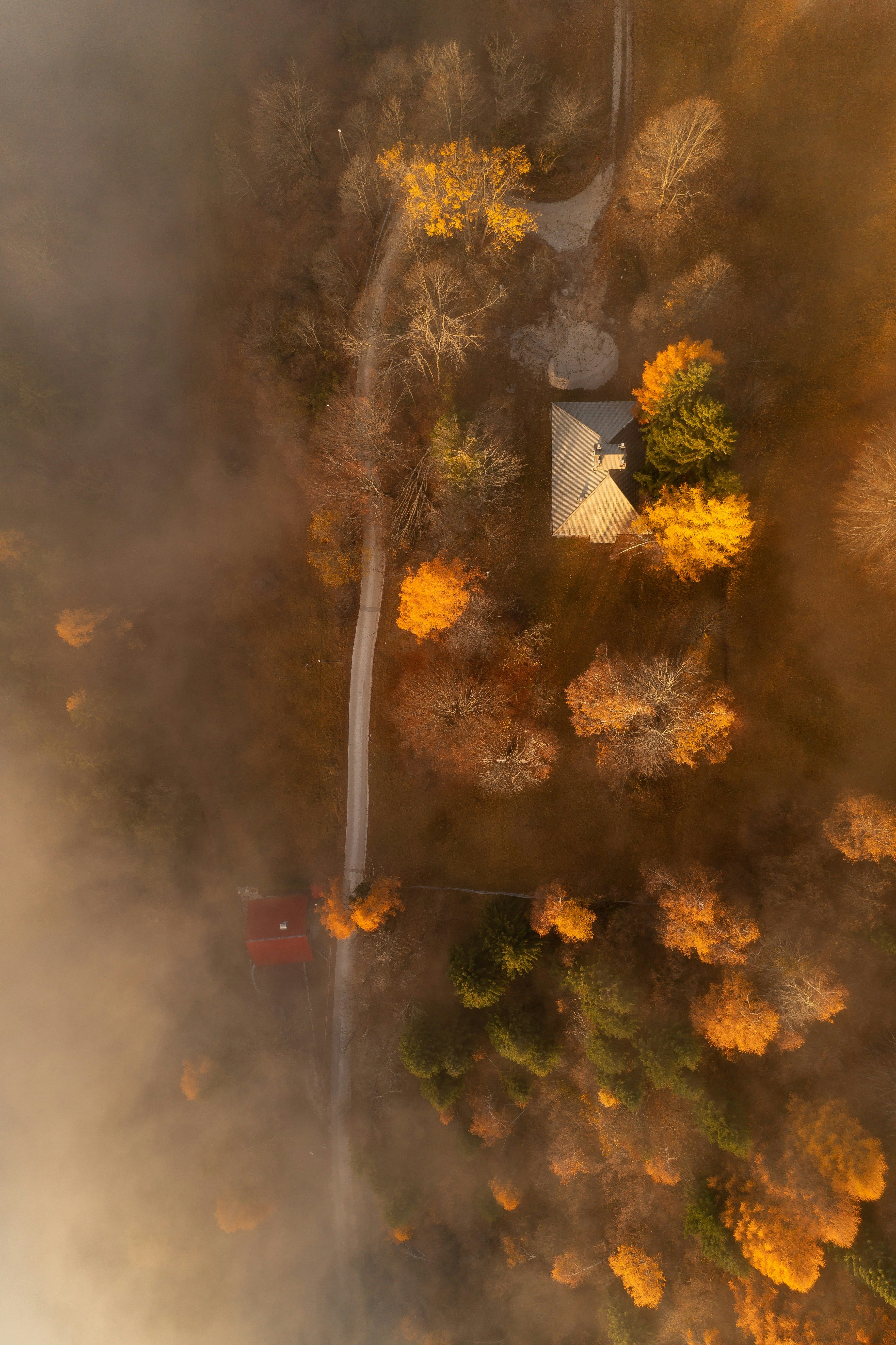
The landscape is shifting, literally. We are experiencing hotter temperatures, longer droughts, and more volatile storms. At the same time, more people are moving into the "urban wildland interface". The shifts have put more structures and people at risk. As a result, vegetation management has evolved from a regulatory compliance chore into a critical line of defense for electric utilities. As wildfire threats escalate and infrastructure becomes more exposed, utilities are no longer asking if vegetation will pose a risk, but when, and how fast they can respond.
In this new era, technology isn’t just supporting vegetation management, it’s redefining it.
Let's explore the process of how utilities are able to lean into technology to be better, faster, AND cheaper.
Legacy Methods: The Burden of Manual Vegetation Management
Before advanced remote sensing and analytics, vegetation management was almost entirely manual. Utility crews patrolled hundreds or thousands of miles of powerlines—on foot, by truck, or by helicopter—with clipboards in hand. Inspections were scheduled on fixed annual or multi-year cycles, regardless of weather conditions, regional fire threats, or vegetation growth rates.
This process was slow, expensive, and deeply inefficient. Crews could only cover a limited amount of territory daily, and documentation was prone to human error or inconsistent standards. The result? Risk often went unseen until it was too late. Entire spans of powerline could be missed due to time or access limitations. In rugged terrain, inspections were even more challenging and dangerous.
The cost burden was also significant. Depending on terrain and access, manual vegetation inspections can cost anywhere from $1,500 to $4,000 per mile, multiplied across tens of thousands of miles. And that doesn’t include the cost of mitigation or emergency response when risks turn into incidents.
This model often meant that vegetation was addressed reactively—after it triggered a fault, damaged equipment, or started a fire. The old approach treated vegetation like a nuisance. Today, it’s treated like a system threat.
Seeing the Risk: Remote Sensing Takes Root
In a world where vegetation risk changes with every season, utilities can’t afford to rely on snapshots in time. That’s where remote sensing delivers its most significant value. Using sensors on satellites, airplanes, and drones, utilities are capturing data at an unprecedented scale—entire regions, not just circuits. These technologies allow operators to continuously see and quantify vegetative change across tens of thousands of miles.
Technologies like imagery, synthetic aperture radar (SAR), and LiDAR provide diverse, complementary perspectives. Each tool captures different attributes of the landscape—structural, spectral, and temporal—giving utilities a fuller picture of what’s growing, changing, and encroaching.
Imagery: Seeing the Landscape in Spectral Detail
Imagery—both multispectral and hyperspectral—offers utilities a powerful lens for detecting and classifying vegetation over large areas. Imagery captures vegetation's light signatures, allowing operators to assess plant health, identify species, and detect stress or disease conditions.
Multispectral imagery, gathered from satellites, crewed aircraft, or drones, provides bands beyond visible light (like near-infrared), essential for calculating vegetation indices such as NDVI (Normalized Difference Vegetation Index). These indices are early warning indicators of drought stress or dieback that could become future hazards. Hyperspectral imagery offers even more granularity, potentially distinguishing between invasive species or tracking specific fuel loads in high-risk areas.
Going Vertical: How LiDAR Is Reshaping the Vegetation Profile
LiDAR, or Light Detection and Ranging, transforms how utilities view vegetative encroachment. Instead of a two-dimensional map, LiDAR offers a 3D point cloud, revealing the vertical profile of vegetation. That means not just the location of trees, but their exact height, spread, and proximity to conductors.
Advanced processing can distinguish tree crowns from undergrowth, estimate clearance distances, and even simulate potential fall-in scenarios. This vertical awareness is a game changer for identifying strike risks before they happen. With regular aerial surveys, utilities can track growth rates over time, enabling predictive maintenance rather than reactive clearing.
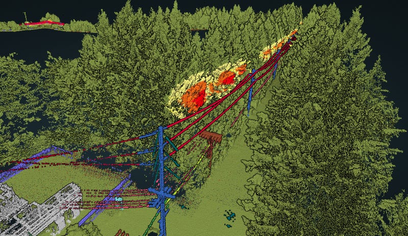
Utilities like PG&E have invested heavily in aerial LiDAR sweeps, creating detailed digital twins of their transmission corridors. These digital environments enable spatial analytics, risk simulations, and data-driven decision-making that weren’t possible with boots on the ground alone.
The Agent of Change: SAR
Synthetic Aperture Radar (SAR) is becoming a quiet powerhouse in the utility monitoring toolkit. Unlike optical sensors, SAR operates day or night, through clouds, smoke, or even haze - conditions that often limit traditional aerial imagery during fire season or in dense weather zones.
Satellite-based SAR excels at capturing surface deformation and vegetative structure change over time. When revisited at regular intervals—sometimes as frequently as every few days—SAR datasets can reveal subtle but meaningful canopy height, biomass density, or ground elevation shifts that indicate soil instability or vegetative overgrowth. These capabilities make SAR invaluable for monitoring vegetation and early warning of land movement in fire-prone or post-burn landscapes.
Because SAR data can be stacked into temporal series, utilities can spot trends that aren't apparent from a single snapshot, such as where vegetation rebounds aggressively after mitigation, or where encroachment patterns are accelerating near high-voltage lines. These temporal insights help inform more nuanced and proactive vegetation strategies.
Satellite vs. Airplane vs. Drone: Choosing the Right Platform for the Mission
Remote sensing platforms vary in coverage, cost, resolution, and responsiveness. Choosing the right tool is a matter of scale, urgency, and the type of insight needed. Below is a high-level comparison of the three dominant platforms utilities use today:
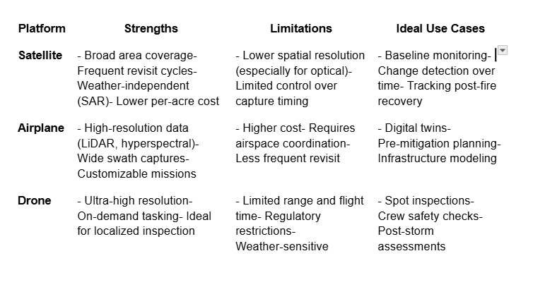
By blending these platforms —satellites for regional change tracking, airplanes for corridor-scale modeling, and drones for targeted inspections—utilities can build a tiered sensing strategy that balances cost, detail, and responsiveness.
What makes imagery so valuable is its frequency. With satellite constellations capturing imagery daily or weekly, utilities can monitor change over time, spot new growth, and make more proactive decisions about where and when to deploy field crews.
Making It Usable: Data Infrastructure for Risk Intelligence
Capturing high-resolution vegetation data is just the first step. The real challenge lies in making it actionable. Utilities are now turning to modern cloud-native platforms capable of storing, indexing, and analyzing vast amounts of remote sensing data. These systems ingest terabytes of LiDAR, imagery, and sensor feeds— geotagged, timestamped, and AI-ready—into organized, searchable repositories.
But data storage alone doesn’t drive decision-making. Utilities are applying advanced analytics and machine learning models to classify vegetation species, assess fuel loads, and predict regrowth rates. These models can flag anomalies like dead or diseased trees and automatically identify locations where clearances are nearing threshold limits.
Interoperability is key. Risk intelligence platforms are tightly integrated with enterprise GIS, SCADA systems, asset registries, and work management software. This allows insights generated in the cloud to inform field action, regulatory reporting, and capital planning. Instead of siloed tools, utilities are building connected ecosystems that bring geospatial intelligence directly into operational workflows.
“The data’s not valuable until it moves—from the sky to the screen, and then to the crews.”
Closing Thought:
Across a range of sensing modalities—imagery, LiDAR, and SAR—and platforms like satellites, crewed aircraft, and drones, utilities are building an unprecedented understanding of vegetative risk. Combining these tools with scalable cloud infrastructure and AI/ML analysis transforms vegetation management from a costly, manual process into a data-driven resilience strategy.
Yet sensing and analysis are just part of the equation. In the next part of this series, we’ll explore how utilities are transferring these insights from dashboards to field crews and how predictive intelligence is reshaping regulatory compliance, operational planning, and climate equity in vegetation programs.
Up next: Rooted in Resilience, Part 3 – From Insight to Action.