Mapping the Future: The Need for a Resilient Geospatial Strategy
From Isolated Insights to Enterprise Foresight — Why Every Organization Needs a Geospatial Strategy

Imagine this: it’s early spring, and a public utility company has completed a vegetation management survey across its mountain service territory. The data was high-quality—airborne LiDAR and multispectral imagery captured every slope, tree, and encroaching limb. The vegetation team used this data to develop a comprehensive and effective annual tree trimming program that reduced the risk to vital electric power lines.
But no one forwarded that dataset to the geohazards group.
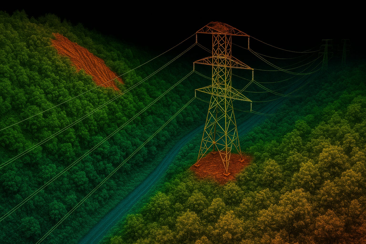
Six weeks later, a saturated hillside failed after a stretch of heavy rainfall. The resulting landslide severed a transmission line, interrupting power to tens of thousands. This failure could have been prevented. The data that could have been used to identify a vulnerable slope was already in the enterprise. It was sitting on a server. It had been collected and processed. It was just never used.
While this is a hypothetical case, it is not an uncommon scenario.
Most organizations today have spatial data. Very few have a spatial strategy.
Across industries, organizations are collecting terabytes of spatial data for a single purpose—vegetation, inspection, permitting—without a broader strategy to repurpose it for risk, resilience, or capital planning. The cost isn’t just redundancy. It is a missed opportunity.
What Is a Geospatial Strategy?
A geospatial strategy is not about buying more software or building a new dashboard. It’s about aligning your organization’s spatial data efforts with its larger goals, whether that’s reducing operational risk, accelerating capital planning, responding faster to climate events, or simply making more intelligent decisions faster.
It asks the right questions:
Why are we collecting spatial data?
Who needs access to it?
How does it flow between teams?
Where does it create value?
At its core, a geospatial strategy helps an organization:
Break down silos between departments
Define standards for data governance and sharing
Identify priority use cases
Connect data to decision-making
Think of it as the connective tissue between sensing and sense-making.
A good strategy doesn’t treat geospatial data as a one-off project. It treats it as an enterprise asset—continuously collected, curated, and leveraged to build a more resilient, adaptive organization.
Why Now? (And Why It’s Not Just GIS Anymore)
The urgency for a geospatial strategy is growing—and it’s not just because there’s more data. It’s because the world organizations operate in is fundamentally more dynamic:
Climate volatility is stressing infrastructure in new ways, making predictive insight a necessity, not a luxury.
Infrastructure investment is surging, and agencies are being asked to do more with public funds, faster.
Digital tools and AI are unlocking new potential—but only if they are grounded in clean, well-structured spatial data.
Compliance and reporting pressures are mounting, and location intelligence is increasingly part of the evidence base.
The era of GIS as a specialized corner function is over. Spatial intelligence now touches every part of the enterprise—from permitting to public safety, from capital planning to climate resilience.
According to a 2020 McKinsey Global Institute study, companies that leverage geospatial and climate risk modeling are better positioned to protect revenue and recover faster from extreme events.¹
In this new reality, having spatial data isn’t enough. What matters is your ability to integrate it, govern it, and act on it consistently and at scale.
The Pillars of a Geospatial Strategy
A strong geospatial strategy rests on five foundational pillars. These aren’t just technical components—they’re organizational commitments:
Vision Alignment
Start with purpose. Your spatial investments should align with top-line business goals: operational resilience, faster permitting, asset optimization, and climate adaptation. If you can’t answer why you’re collecting the data, the strategy is already off course.Data Stewardship
Spatial data often lives in silos or lacks standardization. A strategy requires clarity around ownership, quality control, metadata standards, storage protocols, and refresh cycles. Think of this as the hygiene layer.Platform & Tooling
It’s not about building a single GIS portal—it’s about enabling access across roles. Analysts, field crews, and executives all need tools tailored to their decision workflows. This includes integration with enterprise systems, cloud access, and mobile compatibility.Talent & Governance
Strategy without stewardship is fragile. Define who is responsible for maintaining datasets, setting standards, and enforcing governance. Invest in training so teams can move from map users to spatial thinkers.Use Case Roadmap
Don’t try to do everything at once. Prioritize a sequence of high-impact use cases, such as site selection, vegetation management, emergency response, and permitting efficiency. Win early, then expand.
When these pillars are in place, spatial data shifts from a technical resource to a strategic asset—one that strengthens foresight, accountability, and long-term value.
Common Pitfalls—and How to Avoid Them
Even well-intentioned efforts can fall short without the proper structure. Here are some common traps to avoid:
Mistaking tools for strategy: Buying a new platform isn’t the same as building a roadmap. Strategy must come first.
Working in silos: If only one department uses the data, you’re underutilizing its value.
Neglecting data quality and governance: Poor metadata and inconsistent updates erode trust in the system.
Skipping change management: A strategy is only as good as its users. Adoption and training matter.
Lack of training and education: Teams need ongoing upskilling to understand both the tools and the strategic value of spatial data. Empowerment starts with literacy.
Overcommitting on scope: Trying to do too much at once often results in stalled momentum. Start focused, then scale.
The key is to treat spatial data as infrastructure, not just information.
From Location Data to Location Advantage
A mature geospatial strategy can deliver tangible outcomes:
Smarter, faster capital decisions
Reduced downtime from environmental hazards
More efficient permitting and compliance workflows
Improved coordination between the field, operations, and executive teams
Better public transparency and accountability
Critically, it can prevent cascading failures, like the hypothetical landslide scenario in the introduction. The slope instability might have been detected if the geohazards group had been empowered to access and analyze the same LiDAR used for vegetation management. Mitigation could have been deployed, and outages could have been avoided.
That’s the difference a strategy makes.
Spatial intelligence is no longer a nice-to-have in a world reshaped by climate change, complexity, and accelerating investment. It’s a foundation for resilience.
Your organization already has the coordinates. A geospatial strategy gives you the map.
¹ McKinsey Global Institute. "Climate risk and response: Physical hazards and socioeconomic impacts," 2020.